
Why Land Surveying Matters Before Any Property Project
Most property projects run into problems that a land survey would have caught. A developer buys a lot and finds out the usable area is smaller than expected. A builder pours a foundation and learns it crosses a setback line. A homeowner adds a structure and gets a notice from the city. Land surveying before any property project is how you avoid all of that. This article covers why it matters and what happens when it gets skipped.
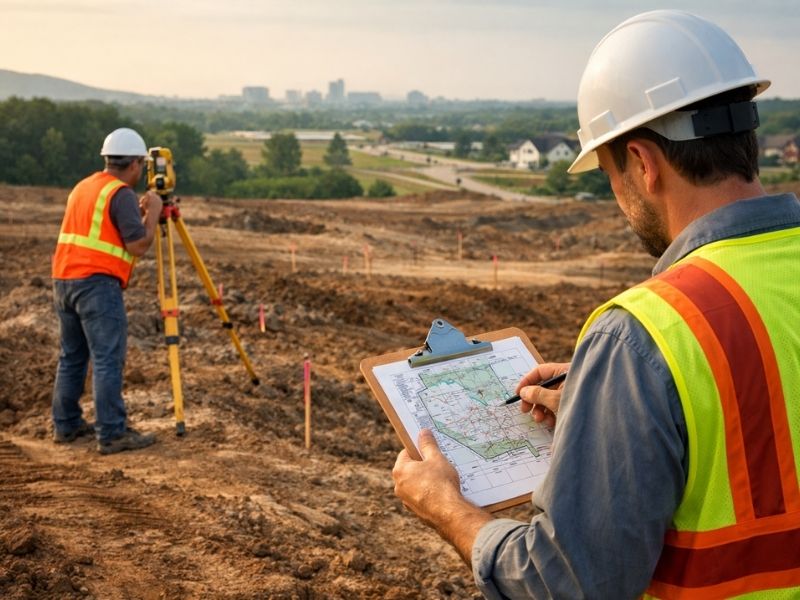
What a Land Survey Actually Confirms
A land survey confirms the legal boundaries of a property. It tells you where your land starts and ends based on recorded documents and field measurements.
It also identifies what’s on or near the property that affects how it can be used. Easements, setbacks and encroachments all show up in survey work. None of those are visible from a site visit or a satellite image.
Without a survey, you’re working with assumptions. Assumptions about where the line is. Assumptions about what the county has on file. Those assumptions are often wrong, and wrong assumptions cost money.
The Real Costs of Skipping a Survey
Boundary disputes are the most common issue. A neighbor builds a fence. You build a wall. One of you is on the wrong side of the line. Without a recorded survey to reference, there’s no clean way to resolve it. Disputes like this end up in court more often than they should.
Setback violations are another problem. Every zoning district has rules about how close a structure can be to a property line or a road. If you don’t know exactly where the line is, you can’t confirm the setback is met. Building departments check this. If the build is wrong, they issue a stop-work order.
Easements are easy to miss without a survey. A utility easement running across the back of a lot can eliminate the exact spot where a developer planned to build. Finding that out after site prep has started is a bad day. Finding it before costs nothing extra.
Encroachments from neighboring properties are also common. A fence, a shed or a driveway from next door may sit on your land. That’s a problem when you try to sell or refinance, and title companies will flag it.
Why Banks and Title Companies Ask for One
Banks don’t lend money on property they can’t verify. A land survey gives them a clear picture of what they’re securing the loan against.
Title companies need it too. Before they issue title insurance, they want to confirm that what’s being insured matches what’s on record. If there’s an encroachment, an unrecorded easement or a boundary issue, they find it in the survey. If those problems exist and aren’t resolved, the policy either won’t be issued or will have exceptions that reduce its value.
Skipping a survey doesn’t avoid those requirements. It just delays them until the worst possible moment, which is usually at closing.
The Right Time to Get a Survey Done
The right time to get a survey is before you commit to anything.
Before you buy, a survey tells you what you’re actually getting. The lot size in a listing may not match the recorded boundary. The usable area may be smaller due to easements or setbacks.
Before you design, survey data gives your engineer or architect accurate information to work from. Designing on bad data means redesigning later, and that costs real money.
Before you break ground, a survey confirms that what you’re about to build is in the right place. That confirmation protects you through every inspection and review that follows.
What the Law Says About Who Can Do It
Only a licensed Professional Land Surveyor can perform and certify a land survey. That’s not a suggestion. It’s the law.
An unlicensed person’s measurements carry no legal weight. Lenders won’t accept them. Title companies won’t accept them. Courts won’t accept them. The license exists because getting boundaries wrong has real consequences for property owners.
Before hiring anyone, verify their license is active. The state board that oversees land surveyors keeps a public directory online. Check it before signing any contract.
How Flood Zones and Land Surveying Connect
Flood zone status affects a lot. It affects what you can build, where you can build it and what your insurance costs will be.
A land survey tied to flood map data can confirm whether a property sits in a Special Flood Hazard Area. That determination affects permitting, construction requirements and loan conditions. Getting it wrong at the start creates problems that don’t surface until a permit review or an insurance application.
If there’s any chance a property is near a flood zone, get this confirmed before you buy or build.
Key Facts Every Developer Should Know
- Alabama requires land surveyors to be licensed under Alabama Code Title 34, Chapter 11.
- Properties in FEMA Special Flood Hazard Areas require flood zone documentation tied directly to survey elevation data.
- Title insurance companies flag boundary issues and encroachments found during survey work before issuing a policy.
- Local building departments use recorded property lines to check setback compliance during permit review.
- An unlicensed surveyor’s work will not be accepted by lenders, title companies or government agencies.
Frequently Asked Questions
Why does land surveying matter before a property project?
A land survey confirms the legal boundaries of a property and identifies easements, setbacks and encroachments before work starts. Without that information, developers risk building in the wrong location, violating zoning rules or facing disputes that delay or stop a project.
Can I rely on an old survey already on file?
An old survey may not reflect current flood map data, recorded easements or changes to the property. Relying on one that’s several years old is risky, especially if the property has been modified or is near a mapped flood zone. A current survey is always the safer choice.
What happens if I build without a survey?
Building without a survey puts you at risk of setback violations, encroachments and permit failures. Local building departments check property lines during inspections. If the build doesn’t match the approved plan, you can get a stop-work order or be required to remove the structure.
How do setbacks relate to land surveying?
Setbacks are minimum distances a structure must be from a property line, road or other feature. A land survey establishes exactly where those lines are. Without a survey, there’s no reliable way to confirm a setback is met before construction starts.
How do I find a licensed land surveyor?
Search the state board of licensure for professional engineers and land surveyors in your state. Verify the license is active before hiring anyone. Only a licensed Professional Land Surveyor can certify work that lenders, title companies and government agencies will accept.